Geolocate

Harbledown topographic map

Click on the map to display elevation.

About this map

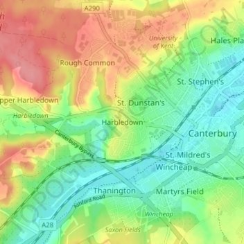
Name: Harbledown topographic map, elevation, terrain.

Location: Harbledown, Canterbury, Kent, England, CT2 8NW, United Kingdom (51.26183 1.03658 51.30183 1.07658)

Average elevation: 135 ft

Minimum elevation: 20 ft

Maximum elevation: 285 ft

Gear up for your next adventure:

🧥Waterproof Jacket for Hiking - Breathable and rugged rain jacket for outdoor excursions
🎒Hydration Pack - Hands‑free water reservoir for long hikes
🌄Hiking Binoculars - Compact binoculars for scenic views and trail spotting
🪵Folding Camp Saw - Compact saw for wood and campsite work
🗺️Topographic Maps - Detailed topo maps for hiking, exploring and outdoor navigation

As an Amazon Associate, this site earns from qualifying purchases at no extra cost to you.