Geolocate

Manila topographic map

Click on the map to display elevation.

About this map

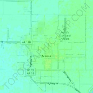
Name: Manila topographic map, elevation, terrain.

Location: Manila, Mississippi County, Arkansas, United States (35.86598 -90.20219 35.90917 -90.14147)

Average elevation: 240 ft

Minimum elevation: 226 ft

Maximum elevation: 253 ft

Mississippi County trails, hiking, mountain biking, running and outdoor activities

Other topographic maps

Click on a map to view its topography, its elevation and its terrain.

Gear up for your next adventure:

🗃️Trail First Aid Kit - Essential kit for outdoor injuries and emergencies
🔭Stargazing Telescopes - Perfect for camping in low-light pollution areas shown on maps
🏫Relief Map Kits - Hands-on tools for teaching landforms and elevation
🧤Hiking Gloves - Protective gloves for rugged trails
🔥Plasma Lighters - Windproof lighters that work in any weather condition

As an Amazon Associate, this site earns from qualifying purchases at no extra cost to you.