
Santa Cruz de Tenerife topographic map
Interactive map
Click on the map to display elevation.
About this map
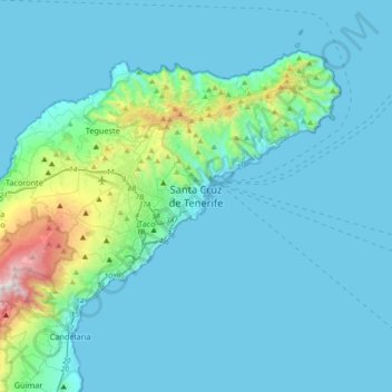
Name: Santa Cruz de Tenerife topographic map, elevation, terrain.
Location: Santa Cruz de Tenerife, Canarische Eilanden, 38004, Spanje (28.30965 -16.41409 28.62965 -16.09409)
Average elevation: 594 ft
Minimum elevation: 0 ft
Maximum elevation: 5,689 ft
Other topographic maps
Click on a map to view its topography, its elevation and its terrain.
La Palmita
Spanje > Canarische Eilanden > Santa Cruz de Tenerife
La Palmita, Santa Cruz de Tenerife, Canarische Eilanden, Spanje
Average elevation: 361 ft