Geolocate

Lucaya topographic map

Click on the map to display elevation.

About this map

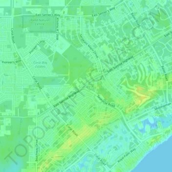
Name: Lucaya topographic map, elevation, terrain.

Location: Lucaya, City of Freeport, Bahamas (26.50376 -78.67974 26.54376 -78.63974)

Average elevation: 23 ft

Minimum elevation: 0 ft

Maximum elevation: 56 ft

Gear up for your next adventure:

🗺️NatGeo Topo Maps - High-quality waterproof printed topographic maps of US Parks
🧯Portable Fire Pit - Compact fire pit for camping spots
Backpacking Tents - Weight-optimized shelters for multi-day topographic surveys
🔦Powerful Headlamps - Ultra-bright hands-free lighting for night navigation
GPS Sports Watch - GPS watch for running, hiking and training

As an Amazon Associate, this site earns from qualifying purchases at no extra cost to you.