Geolocate

Cornville topographic map

Click on the map to display elevation.

About this map

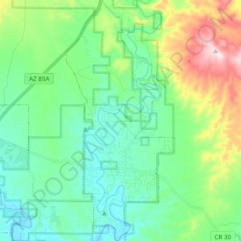
Name: Cornville topographic map, elevation, terrain.

Location: Cornville, Yavapai County, Arizona, 86325, United States (34.68508 -111.93650 34.79391 -111.87597)

Average elevation: 3,704 ft

Minimum elevation: 3,212 ft

Maximum elevation: 5,098 ft

Yavapai County trails, hiking, mountain biking, running and outdoor activities

Gear up for your next adventure:

🌲Outdoor Survival Books - Best books on survival skills
🧯Emergency Survival Kit - All‑in‑one survival essentials for the backcountry
🪶LED Camping Lantern - Bright lantern for camp lighting
📻Weather Alert Radios - Stay informed of storm risks while off-the-grid
🖼️Topo Map Wall Art - Decorative topographic prints of famous peaks and regions

As an Amazon Associate, this site earns from qualifying purchases at no extra cost to you.