
Make a donation
Gear up for your next adventure:
As an Amazon Associate, this site earns from qualifying purchases at no extra cost to you.
Weitnau topographic map
Click on the map to display elevation.
Make a donation
Gear up for your next adventure:
As an Amazon Associate, this site earns from qualifying purchases at no extra cost to you.
Weitnau
• Argental Skilifte; Two ski lifts offer well-prepared pistes for beginners and seasoned skiers and snowboarders. The 500-metre-long family lift, a modern T-bar lift with a difference in altitude of 120 metres, was completely rebuilt in the early 2000s. In addition, there is a 100-metre beginners lift with a difference in altitude of 20 metres. Right next to the beginners lift, a short run is usually prepared for sledges and toboggans. The "Cafe Widdumstüble" provides food as well as hot and cold drinks. Weitnau's cross-country skiing network has its starting point here and is regularly tracked from here.
Make a donation
Gear up for your next adventure:
As an Amazon Associate, this site earns from qualifying purchases at no extra cost to you.
About this map
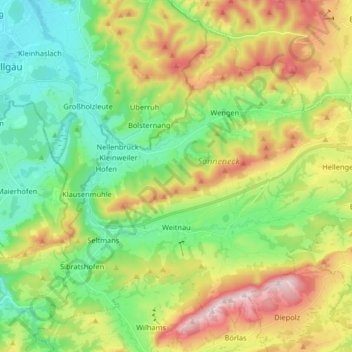
Name: Weitnau topographic map, elevation, terrain.
Average elevation: 2,910 ft
Minimum elevation: 2,260 ft
Maximum elevation: 4,055 ft
Make a donation
Gear up for your next adventure:
As an Amazon Associate, this site earns from qualifying purchases at no extra cost to you.
Other topographic maps
Click on a map to view its topography, its elevation and its terrain.
Immenstadt im Allgäu
Germany > Bavaria > Landkreis Oberallgäu > Immenstadt im Allgäu
Average elevation: 2,986 ft
Make a donation
Gear up for your next adventure:
As an Amazon Associate, this site earns from qualifying purchases at no extra cost to you.
Holdenried
Germany > Bavaria > Landkreis Oberallgäu > Wiggensbach > Wiggensbach
Average elevation: 2,966 ft
Make a donation
Gear up for your next adventure:
As an Amazon Associate, this site earns from qualifying purchases at no extra cost to you.
Make a donation
Gear up for your next adventure:
As an Amazon Associate, this site earns from qualifying purchases at no extra cost to you.