Sierra Nevada topographic map
Click on the map to display elevation.
Sierra Nevada
Parts of the range have been included in the Sierra Nevada National Park. The range has also been declared a biosphere reserve. The Sierra Nevada Observatory, the Calar Alto Observatory, and the IRAM 30m telescope are located on the northern slopes at an elevation of 2,800 metres (9,200 ft).
About this map
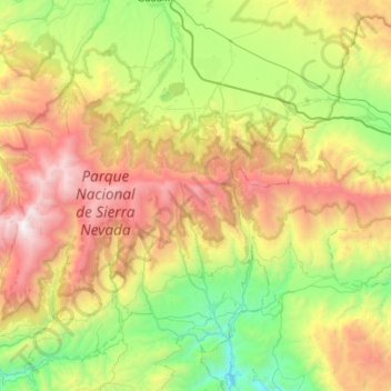
Name: Sierra Nevada topographic map, elevation, terrain.
Location: Sierra Nevada, Comarca de Guadix, Granada, Andalusia, Spain (36.96485 -3.47465 37.11643 -2.75624)
Average elevation: 4,298 ft
Minimum elevation: 0 ft
Maximum elevation: 11,322 ft
Other topographic maps
Click on a map to view its topography, its elevation and its terrain.