
Jukskei River topographic map
Interactive map
Click on the map to display elevation.
About this map
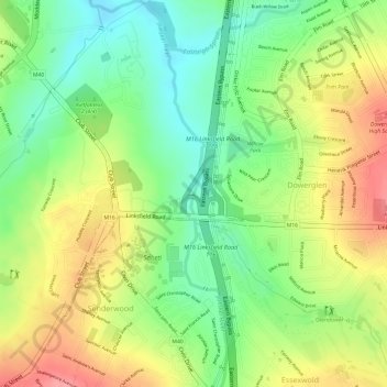
Name: Jukskei River topographic map, elevation, terrain.
Average elevation: 5,223 ft
Minimum elevation: 5,069 ft
Maximum elevation: 5,390 ft
Other topographic maps
Click on a map to view its topography, its elevation and its terrain.
Jukskei River
Jukskei River, Sandton, City of Johannesburg Metropolitan Municipality, Gauteng, 1620, RSA
Average elevation: 5,144 ft
Johannesburg Ward 74
Johannesburg Ward 74, Sandton, City of Johannesburg Metropolitan Municipality, Gauteng, RSA
Average elevation: 5,374 ft
Johannesburg Ward 106
Johannesburg Ward 106, Sandton, City of Johannesburg Metropolitan Municipality, Gauteng, RSA
Average elevation: 4,833 ft
Johannesburg Ward 112
Johannesburg Ward 112, Sandton, City of Johannesburg Metropolitan Municipality, Gauteng, RSA
Average elevation: 4,984 ft
Johannesburg Ward 102
Johannesburg Ward 102, Sandton, City of Johannesburg Metropolitan Municipality, Gauteng, 2125, RSA
Average elevation: 5,059 ft