
Hukarere topographic map
Interactive map
Click on the map to display elevation.
About this map
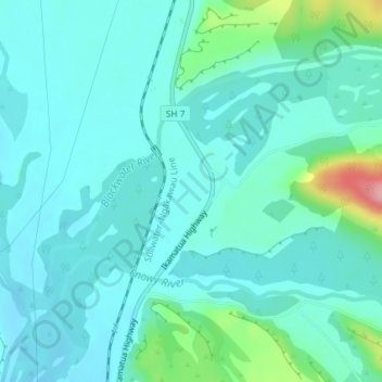
Name: Hukarere topographic map, elevation, terrain.
Location: Hukarere, Buller District, West Coast, New Zealand (-42.25608 171.69046 -42.23608 171.71046)
Average elevation: 430 ft
Minimum elevation: 348 ft
Maximum elevation: 817 ft
Other topographic maps
Click on a map to view its topography, its elevation and its terrain.
Mokihinui
New Zealand > West Coast > Buller District
Mokihinui, Buller District, West Coast, New Zealand
Average elevation: 180 ft
Charleston
New Zealand > West Coast > Buller District
Charleston, Buller District, West Coast, New Zealand
Average elevation: 79 ft
Granity
New Zealand > West Coast > Buller District
Granity, Buller District, West Coast, New Zealand
Average elevation: 492 ft
Lewis Pass
New Zealand > West Coast > Buller District
Lewis Pass, Buller District, West Coast, New Zealand
Average elevation: 3,409 ft
Cape Foulwind
New Zealand > West Coast > Buller District > Cape Foulwind
Cape Foulwind, Buller District, West Coast, New Zealand
Average elevation: 46 ft
Ikamatua
New Zealand > West Coast > Buller District
Ikamatua, Buller District, West Coast, New Zealand
Average elevation: 400 ft
Westport
New Zealand > West Coast > Buller District
Westport, Buller District, West Coast, 7825, New Zealand
Average elevation: 43 ft
Reefton
New Zealand > West Coast > Buller District
Reefton, Buller District, West Coast, 7830, New Zealand
Average elevation: 1,017 ft