
Kanakakkunnu Palace topographic map
Interactive map
Click on the map to display elevation.
About this map
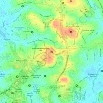
Name: Kanakakkunnu Palace topographic map, elevation, terrain.
Average elevation: 115 ft
Minimum elevation: 46 ft
Maximum elevation: 200 ft
Other topographic maps
Click on a map to view its topography, its elevation and its terrain.
Kalliyoor
India > Kerala > Thiruvananthapuram > Thiruvananthapuram
Kalliyoor, Thiruvananthapuram, Thiruvananthapuram District, Kerala, 695001, India
Average elevation: 98 ft
Chavadimukku
India > Kerala > Thiruvananthapuram > Thiruvananthapuram
Chavadimukku, Sreekariyam, Thiruvananthapuram, Kerala, 695001, India
Average elevation: 128 ft
Aakkulam Lake
India > Kerala > Thiruvananthapuram > Thiruvananthapuram
Aakkulam Lake, Akkulam, Thiruvananthapuram, Thiruvananthapuram District, Kerala, 695001, India
Average elevation: 39 ft