
Make a donation
Gear up for your next adventure:
As an Amazon Associate, this site earns from qualifying purchases at no extra cost to you.
Pardubický kraj topographic map
Click on the map to display elevation.
Make a donation
Gear up for your next adventure:
As an Amazon Associate, this site earns from qualifying purchases at no extra cost to you.
Pardubický kraj
Precipitation is relatively lower in the central part of the region where the total annual values are around 700 – 800 mm. In the areas with higher elevation (such as Žďárské Vrchy or the foothills of Orlické Hory) there is higher precipitation with annual values of 800 – 1,000 mm.
Make a donation
Gear up for your next adventure:
As an Amazon Associate, this site earns from qualifying purchases at no extra cost to you.
About this map
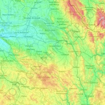
Name: Pardubický kraj topographic map, elevation, terrain.
Location: Pardubický kraj, Northeast, Czechia (49.57213 15.36281 50.20764 16.86739)
Average elevation: 1,496 ft
Minimum elevation: 659 ft
Maximum elevation: 4,665 ft
Make a donation
Gear up for your next adventure:
As an Amazon Associate, this site earns from qualifying purchases at no extra cost to you.
Other topographic maps
Click on a map to view its topography, its elevation and its terrain.
Make a donation
Gear up for your next adventure:
As an Amazon Associate, this site earns from qualifying purchases at no extra cost to you.
Make a donation
Gear up for your next adventure:
As an Amazon Associate, this site earns from qualifying purchases at no extra cost to you.