
Sarita Vihar Tehsil topographic map
Interactive map
Click on the map to display elevation.
About this map
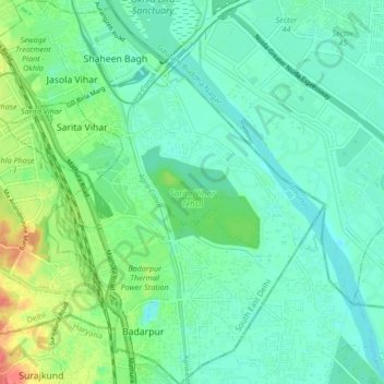
Name: Sarita Vihar Tehsil topographic map, elevation, terrain.
Location: Sarita Vihar Tehsil, South East Delhi District, Delhi, India (28.48402 77.27021 28.55776 77.34660)
Average elevation: 673 ft
Minimum elevation: 623 ft
Maximum elevation: 810 ft
Other topographic maps
Click on a map to view its topography, its elevation and its terrain.
Seelam Pur Tehsil
Seelam Pur Tehsil, North East Delhi District, Delhi, India
Average elevation: 682 ft
Mehrauli Tehsil
Mehrauli Tehsil, South Delhi District, Delhi, India
Average elevation: 837 ft
Timarpur
India > Delhi > Civil Lines Tehsil
Timarpur, Civil Lines Tehsil, Central Delhi, Delhi, India
Average elevation: 699 ft
Kidwai Nagar East
India > Delhi > Defence Colony Tehsil
Kidwai Nagar East, Defence Colony Tehsil, South East Delhi, Delhi, India
Average elevation: 709 ft
Dwarka Tehsil
India > Delhi > Dwarka Tehsil
Dwarka Tehsil, South West Delhi, Delhi, India
Average elevation: 709 ft
Punjabi Bagh Tehsil
India > Delhi > Punjabi Bagh Tehsil
Punjabi Bagh Tehsil, West Delhi, Delhi, India
Average elevation: 709 ft
Najafgarh Tehsil
India > Delhi > Najafgarh Tehsil
Najafgarh Tehsil, South West Delhi, Delhi, India
Average elevation: 702 ft
Alipur Tehsil
India > Delhi > Alipur Tehsil
Alipur Tehsil, North Delhi, Delhi, India
Average elevation: 696 ft
Delhi
India > Delhi > Kotwali Tehsil
Delhi, Kotwali Tehsil, Central Delhi, Delhi, 110006, India
Average elevation: 709 ft
Nishat Park
Nishat Park, Dwarka, South West Delhi, Delhi, India
Average elevation: 702 ft
Jhandewalan
Jhandewalan, Delhi, Central Delhi, Delhi, India
Average elevation: 751 ft