
Thank you for supporting this site ❤️
Make a donation
Make a donation
Gear up for your next adventure:
As an Amazon Associate, this site earns from qualifying purchases at no extra cost to you.
Erbach topographic map
Click on the map to display elevation.
Thank you for supporting this site ❤️
Make a donation
Make a donation
Gear up for your next adventure:
As an Amazon Associate, this site earns from qualifying purchases at no extra cost to you.
Erbach
The town lies in the Mittelgebirge Odenwald at elevations between 200 and 560 m in the valley of the Mümling.
Thank you for supporting this site ❤️
Make a donation
Make a donation
Gear up for your next adventure:
As an Amazon Associate, this site earns from qualifying purchases at no extra cost to you.
About this map
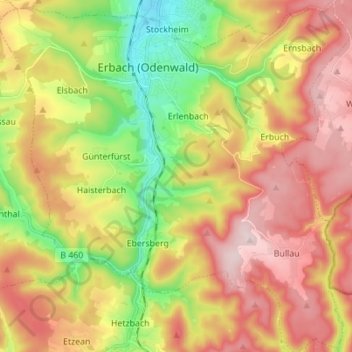
Name: Erbach topographic map, elevation, terrain.
Location: Erbach, Odenwaldkreis, Hesse, 64711, Germany (49.58575 8.93678 49.67495 9.07457)
Average elevation: 1,293 ft
Minimum elevation: 663 ft
Maximum elevation: 1,873 ft
Thank you for supporting this site ❤️
Make a donation
Make a donation
Gear up for your next adventure:
As an Amazon Associate, this site earns from qualifying purchases at no extra cost to you.