
San Luis Potosí topographic map
Interactive map
Click on the map to display elevation.
About this map
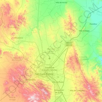
Name: San Luis Potosí topographic map, elevation, terrain.
Location: San Luis Potosí, México (21.95761 -101.16851 22.66066 -100.74204)
Average elevation: 6,358 ft
Minimum elevation: 4,731 ft
Maximum elevation: 9,341 ft
Other topographic maps
Click on a map to view its topography, its elevation and its terrain.
Soledad de Graciano Sánchez
México > San Luis Potosí > Soledad de Graciano Sánchez
Soledad de Graciano Sánchez, San Luis Potosí, 78430, México
Average elevation: 6,076 ft