Geolocate

Gavi topographic map

Click on the map to display elevation.

About this map

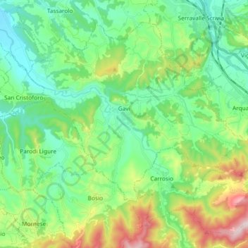
Name: Gavi topographic map, elevation, terrain.

Location: Gavi, Alessandria, Piedmont, 15066, Italy (44.63746 8.74355 44.72461 8.88956)

Average elevation: 1,004 ft

Minimum elevation: 515 ft

Maximum elevation: 2,260 ft

Other topographic maps

Click on a map to view its topography, its elevation and its terrain.

Po

Italy > Piedmont > Alessandria > Coniolo

Average elevation: 479 ft

Rosingo

Italy > Piedmont > Alessandria > Cerrina Monferrato

Average elevation: 768 ft

Valle Scura

Italy > Piedmont > Alessandria > Brignano-Frascata

Average elevation: 1,299 ft

Molini

Italy > Piedmont > Alessandria > Fraconalto

Average elevation: 2,047 ft

Zanco

Italy > Piedmont > Alessandria > Villadeati

Average elevation: 791 ft

Ciglione

Italy > Piedmont > Alessandria > Ponzone

Average elevation: 1,270 ft

Gnocchetto

Italy > Piedmont > Alessandria > Ovada

Average elevation: 1,401 ft

Mandrogne

Italy > Piedmont > Alessandria > Alessandria

Average elevation: 394 ft

Incisa

Italy > Piedmont > Alessandria > Montacuto

Average elevation: 1,749 ft

Gear up for your next adventure:

🚗GPS Dash Cams - Record your scenic drives through mountain passes and canyons
🪓Survival Multi‑Tool - Versatile tool for camp and trail tasks
🏔️Mountain Trail Maps - High‑detail maps for popular peaks
🧥Men's Rain Shells - Premium waterproof and breathable jackets for mountain weather
📚Navigation Handbooks - Master the art of reading topographic maps and using a compass

As an Amazon Associate, this site earns from qualifying purchases at no extra cost to you.