
Appenzell topographic map
Interactive map
Click on the map to display elevation.
About this map
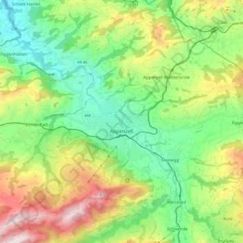
Name: Appenzell topographic map, elevation, terrain.
Location: Appenzell, Appenzell Innerrhoden, 9050, Zwitserland (47.30427 9.37190 47.36127 9.47923)
Average elevation: 3,084 ft
Minimum elevation: 2,244 ft
Maximum elevation: 4,469 ft
De gemeente bestaat uit de dorpen Appenzell, Rinkenbach, Kau en Meistersrüte en ligt op 780 meter hoogte en beslaat 1688 hectare (16,88 km²). Appenzell telt 5.729 inwoners.
Other topographic maps
Click on a map to view its topography, its elevation and its terrain.
Oberegg
Zwitserland > Appenzell Innerrhoden > Oberegg
Oberegg, Appenzell Innerrhoden, 9413, Zwitserland
Average elevation: 2,556 ft