
Make a donation
Gear up for your next adventure:
As an Amazon Associate, this site earns from qualifying purchases at no extra cost to you.
Mount Pinatubo topographic map
Click on the map to display elevation.
Make a donation
Gear up for your next adventure:
As an Amazon Associate, this site earns from qualifying purchases at no extra cost to you.
Mount Pinatubo
Even before the 1991 eruption, Mount Pinatubo had little topographic prominence: it was 1,745 m (5,725 ft) above sea level, only about 600 m (2,000 ft) above nearby plains, and only about 200 m (660 ft) higher than surrounding peaks, which largely obscured it from view. It is part of a chain of volcanoes which lie along the western side of the island of Luzon called the Zambales Mountains.
Make a donation
Gear up for your next adventure:
As an Amazon Associate, this site earns from qualifying purchases at no extra cost to you.
About this map
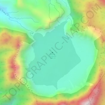
Name: Mount Pinatubo topographic map, elevation, terrain.
Location: Mount Pinatubo, Zambales, Central Luzon, Philippines (15.14451 120.34901 15.14461 120.34911)
Average elevation: 3,435 ft
Minimum elevation: 2,687 ft
Maximum elevation: 4,672 ft
Make a donation
Gear up for your next adventure:
As an Amazon Associate, this site earns from qualifying purchases at no extra cost to you.
Other topographic maps
Click on a map to view its topography, its elevation and its terrain.
Make a donation
Gear up for your next adventure:
As an Amazon Associate, this site earns from qualifying purchases at no extra cost to you.
Make a donation
Gear up for your next adventure:
As an Amazon Associate, this site earns from qualifying purchases at no extra cost to you.
Make a donation
Gear up for your next adventure:
As an Amazon Associate, this site earns from qualifying purchases at no extra cost to you.
Make a donation
Gear up for your next adventure:
As an Amazon Associate, this site earns from qualifying purchases at no extra cost to you.