
Make a donation
Gear up for your next adventure:
As an Amazon Associate, this site earns from qualifying purchases at no extra cost to you.
Mokopane topographic map
Click on the map to display elevation.
Make a donation
Gear up for your next adventure:
As an Amazon Associate, this site earns from qualifying purchases at no extra cost to you.
About this map
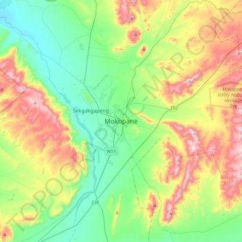
Name: Mokopane topographic map, elevation, terrain.
Average elevation: 4,216 ft
Minimum elevation: 3,307 ft
Maximum elevation: 5,958 ft
Make a donation
Gear up for your next adventure:
As an Amazon Associate, this site earns from qualifying purchases at no extra cost to you.
Other topographic maps
Click on a map to view its topography, its elevation and its terrain.
Mogalakwena
South Africa > Limpopo > Waterberg District Municipality > Mogalakwena Local Municipality
Average elevation: 2,805 ft
Marakele National Park
South Africa > Limpopo > Waterberg District Municipality
Average elevation: 4,373 ft
Thabazimbi Ward 4
South Africa > Limpopo > Waterberg District Municipality > Thabazimbi Local Municipality
Average elevation: 3,612 ft
Mookgopong Local Municipality
South Africa > Limpopo > Waterberg District Municipality
Average elevation: 3,757 ft
Make a donation
Gear up for your next adventure:
As an Amazon Associate, this site earns from qualifying purchases at no extra cost to you.
Lapalala Wilderness Reserve
South Africa > Limpopo > Waterberg District Municipality
Average elevation: 3,727 ft
Modimolle Ward 2
South Africa > Limpopo > Waterberg District Municipality > Modimolle Local Municipality
Average elevation: 4,147 ft
Mabalingwe Nature Reserve
South Africa > Limpopo > Waterberg District Municipality > Bela Bela Local Municipality
Average elevation: 4,236 ft
Bela Bela Local Municipality
South Africa > Limpopo > Waterberg District Municipality
Average elevation: 3,750 ft
Make a donation
Gear up for your next adventure:
As an Amazon Associate, this site earns from qualifying purchases at no extra cost to you.
Doorndraai Dam
South Africa > Limpopo > Waterberg District Municipality > Mookgopong Local Municipality
Average elevation: 4,127 ft
Mogalakwena Local Municipality
South Africa > Limpopo > Waterberg District Municipality
Average elevation: 3,829 ft
Modimolle Local Municipality
South Africa > Limpopo > Waterberg District Municipality
Average elevation: 4,177 ft
Mokolo Dam
South Africa > Limpopo > Waterberg District Municipality > Lephalale Local Municipality
Average elevation: 3,402 ft
Make a donation
Gear up for your next adventure:
As an Amazon Associate, this site earns from qualifying purchases at no extra cost to you.
Welgevonden Nature Reserve
South Africa > Limpopo > Waterberg District Municipality > Mokopane
Average elevation: 4,449 ft
Mogalakwena Local Municipality
South Africa > Limpopo > Waterberg District Municipality
Average elevation: 3,829 ft
Mogalakwena River
South Africa > Limpopo > Waterberg District Municipality > Mokopane
Average elevation: 3,537 ft
Modimolle Local Municipality
South Africa > Limpopo > Waterberg District Municipality
Average elevation: 4,177 ft
Make a donation
Gear up for your next adventure:
As an Amazon Associate, this site earns from qualifying purchases at no extra cost to you.
Lephalale Local Municipality
South Africa > Limpopo > Waterberg District Municipality
Average elevation: 3,251 ft
Thabazimbi Local Municipality
South Africa > Limpopo > Waterberg District Municipality
Average elevation: 3,314 ft
Lapalala Wilderness Reserve
South Africa > Limpopo > Waterberg District Municipality
Average elevation: 3,727 ft
Modimolle Local Municipality
South Africa > Limpopo > Waterberg District Municipality
Average elevation: 4,177 ft
Make a donation
Gear up for your next adventure:
As an Amazon Associate, this site earns from qualifying purchases at no extra cost to you.
Lapalala Wilderness Reserve
South Africa > Limpopo > Waterberg District Municipality
Average elevation: 3,727 ft
Mogalakwena Ward 16
South Africa > Limpopo > Waterberg District Municipality > Mogalakwena Local Municipality
Average elevation: 3,904 ft
Nylsvley Nature Reserve
South Africa > Limpopo > Waterberg District Municipality > Mookgopong Local Municipality
Average elevation: 3,622 ft