
Vale das Gatas topographic map
Interactive map
Click on the map to display elevation.
About this map
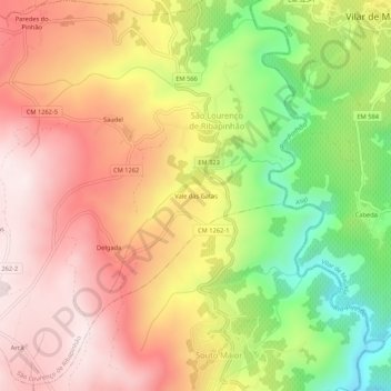
Name: Vale das Gatas topographic map, elevation, terrain.
Average elevation: 1,982 ft
Minimum elevation: 951 ft
Maximum elevation: 2,779 ft
Other topographic maps
Click on a map to view its topography, its elevation and its terrain.
Saudel
Portugal > Vila Real > Sabrosa > São Lourenço de Ribapinhão
Saudel, São Lourenço de Ribapinhão, Sabrosa, Vila Real, 5000-121, Portugal
Average elevation: 2,169 ft