
Ringingen topographic map
Interactive map
Click on the map to display elevation.
About this map
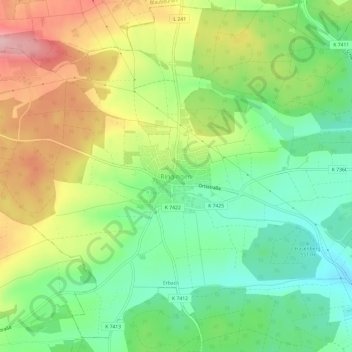
Name: Ringingen topographic map, elevation, terrain.
Average elevation: 1,903 ft
Minimum elevation: 1,663 ft
Maximum elevation: 2,247 ft
Other topographic maps
Click on a map to view its topography, its elevation and its terrain.
89155
Deutschland > Baden-Württemberg > Alb-Donau-Kreis > Erbach > Donaurieden
89155, Donaurieden, Erbach, Alb-Donau-Kreis, Baden-Württemberg, Deutschland
Average elevation: 1,631 ft
Dellmensingen
Deutschland > Baden-Württemberg > Alb-Donau-Kreis > Erbach
Dellmensingen, Erbach, Alb-Donau-Kreis, Baden-Württemberg, 89155, Deutschland
Average elevation: 1,608 ft
Steinenfeld
Deutschland > Baden-Württemberg > Alb-Donau-Kreis > Erbach > Steinenfeld
Steinenfeld, Erbach, Alb-Donau-Kreis, Baden-Württemberg, 89155, Deutschland
Average elevation: 2,077 ft