
Parque Vistas de Oriente 2da Seccion topographic map
Interactive map
Click on the map to display elevation.
About this map
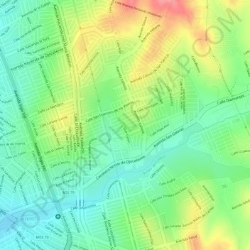
Name: Parque Vistas de Oriente 2da Seccion topographic map, elevation, terrain.
Average elevation: 6,381 ft
Minimum elevation: 6,247 ft
Maximum elevation: 6,572 ft
Other topographic maps
Click on a map to view its topography, its elevation and its terrain.
Isla San Marcos
México > Aguascalientes > Aguascalientes
Isla San Marcos, Colonia España, Los Negritos, Aguascalientes, México
Average elevation: 6,063 ft