
Warwick topographic map
Interactive map
Click on the map to display elevation.
About this map
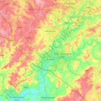
Name: Warwick topographic map, elevation, terrain.
Location: Warwick, Warwickshire, England, United Kingdom (52.21370 -1.78018 52.38928 -1.40608)
Average elevation: 285 ft
Minimum elevation: 115 ft
Maximum elevation: 476 ft
Warwick experiences the usual English maritime climate, marked by a narrow temperature range, mild winters and cool summers. The nearest official Met Office weather station is at Wellesbourne, about 6 miles (10 km) south of the town centre and at a similar elevation. The absolute maximum temperature (also the absolute maximum for the county of Warwickshire) stands at 36.1 °C (97.0 °F) recorded in August 1990. During a typical year, the warmest day should reach 30.0 °C (86.0 °F), and 16.5 days should report a maximum of 25.1 °C (77.2 °F) or higher. The lowest recorded temperature is −17.8 °C (0.0 °F), recorded in January 1982. Typically, 53.3 air frosts are recorded in an "average" year. Rainfall averages out at 608 millimetres (23.9 in) per year, with over 114 days seeing 1 mm (0.04 in) or more falling. All averages refer to the 1971–2000 period.
Other topographic maps
Click on a map to view its topography, its elevation and its terrain.
Clifton upon Dunsmore CP
United Kingdom > England > Warwickshire > Rugby
Clifton upon Dunsmore CP, Rugby, Warwickshire, England, United Kingdom
Average elevation: 354 ft
Draycote Water
United Kingdom > England > Warwickshire > Rugby > Draycote
Draycote Water, Draycote, Rugby, Warwickshire, England, United Kingdom
Average elevation: 302 ft
Harbury
United Kingdom > England > Warwickshire > Stratford-on-Avon
Harbury, Stratford-on-Avon, Warwickshire, England, United Kingdom
Average elevation: 312 ft
Binton
United Kingdom > England > Warwickshire > Stratford-on-Avon
Binton, Stratford-on-Avon, Warwickshire, England, CV37 9TL, United Kingdom
Average elevation: 197 ft
Burton Dassett Hills Country Park
United Kingdom > England > Warwickshire > Stratford-on-Avon > Northend > Burton Dassett CP
Burton Dassett Hills Country Park, Burton Dassett CP, Northend, Stratford-on-Avon, Warwickshire, England, United Kingdom
Average elevation: 433 ft
Alveston
United Kingdom > England > Warwickshire > Stratford-on-Avon
Alveston, Stratford-on-Avon, Warwickshire, England, CV37 7QT, United Kingdom
Average elevation: 164 ft
Rugby
United Kingdom > England > Warwickshire
Rugby, Warwickshire, England, United Kingdom
Average elevation: 367 ft
Alcester
United Kingdom > England > Warwickshire > Stratford-on-Avon
Alcester, Stratford-on-Avon, Warwickshire, England, United Kingdom
Average elevation: 203 ft
Nuneaton
United Kingdom > England > Warwickshire > Nuneaton and Bedworth
Nuneaton, Nuneaton and Bedworth, Warwickshire, England, CV11 5AB, United Kingdom
Average elevation: 331 ft
Warmington CP
United Kingdom > England > Warwickshire > Stratford-on-Avon
Warmington CP, Stratford-on-Avon, Warwickshire, England, United Kingdom
Average elevation: 476 ft
Newton
United Kingdom > England > Warwickshire > Rugby
Newton, Rugby, Warwickshire, England, CV23 0EE, United Kingdom
Average elevation: 374 ft
Kineton CP
United Kingdom > England > Warwickshire > Stratford-on-Avon
Kineton CP, Stratford-on-Avon, Warwickshire, England, United Kingdom
Average elevation: 305 ft
Cranhill
United Kingdom > England > Warwickshire > Stratford-on-Avon > Ardens Grafton
Cranhill, Temple Grafton CP, Ardens Grafton, Stratford-on-Avon, Warwickshire, England, B50 4LW, United Kingdom
Average elevation: 187 ft
Gaydon
United Kingdom > England > Warwickshire > Stratford-on-Avon > Gaydon
Gaydon, Stratford-on-Avon, Warwickshire, England, United Kingdom
Average elevation: 358 ft
Bishops Itchington
United Kingdom > England > Warwickshire > Stratford-on-Avon > Bishop's Itchington
Bishops Itchington, Bishop's Itchington, Stratford-on-Avon, Warwickshire, England, United Kingdom
Average elevation: 341 ft
Shipston-on-Stour
United Kingdom > England > Warwickshire > Stratford-on-Avon
Shipston-on-Stour, Stratford-on-Avon, Warwickshire, England, CV36 4AJ, United Kingdom
Average elevation: 272 ft
Long Marston CP
United Kingdom > England > Warwickshire > Stratford-on-Avon
Long Marston CP, Stratford-on-Avon, Warwickshire, England, United Kingdom
Average elevation: 148 ft
Wellesbourne
United Kingdom > England > Warwickshire > Stratford-on-Avon > Wellesbourne
Wellesbourne, Stratford-on-Avon, Warwickshire, England, CV35 9SJ, United Kingdom
Average elevation: 226 ft
Cherington
United Kingdom > England > Warwickshire > Stratford-on-Avon
Cherington, Stratford-on-Avon, Warwickshire, England, CV36 5HS, United Kingdom
Average elevation: 390 ft
Stratford-upon-Avon
United Kingdom > England > Warwickshire > Stratford-on-Avon
Stratford-upon-Avon, Stratford-on-Avon, Warwickshire, England, United Kingdom
Average elevation: 200 ft
Royal Leamington Spa
United Kingdom > England > Warwickshire
Royal Leamington Spa, Warwick, Warwickshire, England, United Kingdom
Average elevation: 217 ft
Ullenhall
United Kingdom > England > Warwickshire > Stratford-on-Avon > Ullenhall
Ullenhall, Stratford-on-Avon, Warwickshire, West Midlands, England, United Kingdom
Average elevation: 348 ft
Newbold on Avon
United Kingdom > England > Warwickshire > Rugby
Newbold on Avon, Rugby, Warwickshire, England, CV21 1HQ, United Kingdom
Average elevation: 322 ft
West Midlands
United Kingdom > England > Warwickshire
West Midlands, Warwickshire, West Midlands Combined Authority, England, United Kingdom
Average elevation: 371 ft
Sutton-under-Brailes
United Kingdom > England > Warwickshire > Stratford-on-Avon > Stourton
Sutton-under-Brailes, Sutton under Brailes, Stourton, Stratford-on-Avon, Warwickshire, England, OX15 5BG, United Kingdom
Average elevation: 410 ft