
Clifton upon Dunsmore CP topographic map
Interactive map
Click on the map to display elevation.
About this map
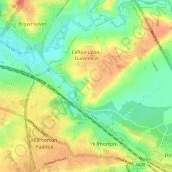
Name: Clifton upon Dunsmore CP topographic map, elevation, terrain.
Average elevation: 354 ft
Minimum elevation: 279 ft
Maximum elevation: 440 ft
Other topographic maps
Click on a map to view its topography, its elevation and its terrain.
Draycote Water
United Kingdom > England > Warwickshire > Rugby > Draycote
Draycote Water, Draycote, Rugby, Warwickshire, England, United Kingdom
Average elevation: 302 ft
Newton
United Kingdom > England > Warwickshire > Rugby
Newton, Rugby, Warwickshire, England, CV23 0EE, United Kingdom
Average elevation: 374 ft
Newbold on Avon
United Kingdom > England > Warwickshire > Rugby
Newbold on Avon, Rugby, Warwickshire, England, CV21 1HQ, United Kingdom
Average elevation: 322 ft