
Haapiti topographic map
Interactive map
Click on the map to display elevation.
About this map
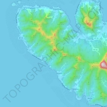
Name: Haapiti topographic map, elevation, terrain.
Average elevation: 364 ft
Minimum elevation: 0 ft
Maximum elevation: 3,957 ft
Other topographic maps
Click on a map to view its topography, its elevation and its terrain.
Moorea
France > Polynésie française > Moorea-Maiao
Moorea, Moorea-Maiao, Îles du Vent, Polynésie française, 98728, France
Average elevation: 282 ft