
Thank you for supporting this site ❤️
Make a donation
Make a donation
Gear up for your next adventure:
As an Amazon Associate, this site earns from qualifying purchases at no extra cost to you.
Fafe topographic map
Click on the map to display elevation.
Thank you for supporting this site ❤️
Make a donation
Make a donation
Gear up for your next adventure:
As an Amazon Associate, this site earns from qualifying purchases at no extra cost to you.
About this map
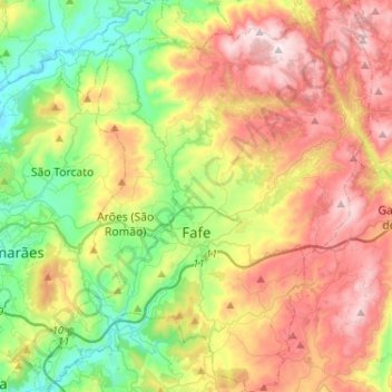
Name: Fafe topographic map, elevation, terrain.
Location: Fafe, Braga, Portugal (41.37283 -8.24796 41.56595 -8.05519)
Average elevation: 1,476 ft
Minimum elevation: 400 ft
Maximum elevation: 2,904 ft
Thank you for supporting this site ❤️
Make a donation
Make a donation
Gear up for your next adventure:
As an Amazon Associate, this site earns from qualifying purchases at no extra cost to you.
Other topographic maps
Click on a map to view its topography, its elevation and its terrain.
Santo António de Mixões da Serra
Portugal > Braga > Valdreu > Santo António de Mixões da Serra
Average elevation: 2,070 ft