
Lindau (Bodensee) topographic map
Interactive map
Click on the map to display elevation.
About this map
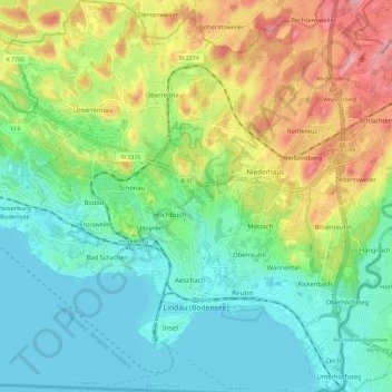
Name: Lindau (Bodensee) topographic map, elevation, terrain.
Location: Lindau (Bodensee), Landkreis Lindau, Bavière, 88131, Allemagne (47.53366 9.63623 47.61207 9.74084)
Average elevation: 1,470 ft
Minimum elevation: 1,283 ft
Maximum elevation: 1,841 ft
Other topographic maps
Click on a map to view its topography, its elevation and its terrain.
Göritz
Allemagne > Bavière > Landkreis Lindau > Opfenbach
Göritz, Opfenbach, Landkreis Lindau, Bavière, 88145, Allemagne
Average elevation: 1,883 ft
Rickenbach
Allemagne > Bavière > Landkreis Lindau > Lindau (Bodensee)
Rickenbach, Lindau (Bodensee), Landkreis Lindau, Bavière, 88131, Allemagne
Average elevation: 1,404 ft
Grünenbach
Allemagne > Bavière > Landkreis Lindau > Grünenbach
Grünenbach, Argental (VGem), Landkreis Lindau, Bavière, 88167, Allemagne
Average elevation: 2,503 ft
Biesings
Allemagne > Bavière > Landkreis Lindau > Schlachters
Biesings, Schlachters, Sigmarszell, Sigmarszell (VGem), Landkreis Lindau, Bavière, 88138, Allemagne
Average elevation: 1,657 ft