
West Augustine topographic map
Interactive map
Click on the map to display elevation.
About this map
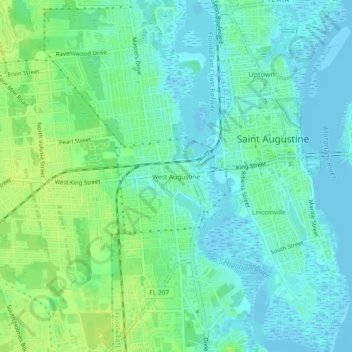
Name: West Augustine topographic map, elevation, terrain.
Average elevation: 20 ft
Minimum elevation: -13 ft
Maximum elevation: 49 ft
Other topographic maps
Click on a map to view its topography, its elevation and its terrain.
Castillo de San Marcos
United States > Florida > Saint Johns County > Saint Augustine
Castillo de San Marcos, 1, South Castillo Drive, Old City, Saint Augustine, Saint Johns County, Florida, 32084, United States
Average elevation: 7 ft
Lincolnville
United States > Florida > Saint Johns County > Saint Augustine
Lincolnville, Saint Augustine, Saint Johns County, Florida, 32084, United States
Average elevation: 13 ft