
Dogwood Hill topographic map
Interactive map
Click on the map to display elevation.
About this map
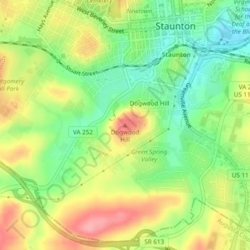
Name: Dogwood Hill topographic map, elevation, terrain.
Location: Dogwood Hill, Staunton, Virginia, 24401, United States (38.13879 -79.07955 38.13889 -79.07945)
Average elevation: 1,506 ft
Minimum elevation: 1,339 ft
Maximum elevation: 1,703 ft
Other topographic maps
Click on a map to view its topography, its elevation and its terrain.
Peyton
United States > Virginia > Staunton
Peyton, Staunton, Virginia, 24401, United States
Average elevation: 1,437 ft