
Hagelberg topographic map
Interactive map
Click on the map to display elevation.
About this map
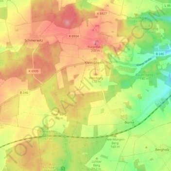
Name: Hagelberg topographic map, elevation, terrain.
Average elevation: 522 ft
Minimum elevation: 348 ft
Maximum elevation: 663 ft
Other topographic maps
Click on a map to view its topography, its elevation and its terrain.
Werbig
Deutschland > Brandenburg > Potsdam-Mittelmark > Bad Belzig
Werbig, Bad Belzig, Potsdam-Mittelmark, Brandenburg, Deutschland
Average elevation: 371 ft
Groß Briesen
Deutschland > Brandenburg > Potsdam-Mittelmark > Bad Belzig
Groß Briesen, Bad Belzig, Potsdam-Mittelmark, Brandenburg, Deutschland
Average elevation: 253 ft
Pumpenberg
Deutschland > Brandenburg > Potsdam-Mittelmark > Bad Belzig
Pumpenberg, Bad Belzig, Potsdam-Mittelmark, Brandenburg, Deutschland
Average elevation: 479 ft