
Kolathur topographic map
Interactive map
Click on the map to display elevation.
About this map
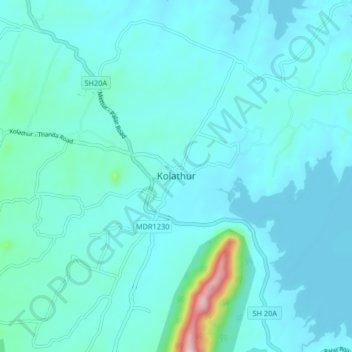
Name: Kolathur topographic map, elevation, terrain.
Location: Kolathur, Mettur, Salem District, Tamil Nadu, 636303, India (11.80847 77.71176 11.88847 77.79176)
Average elevation: 899 ft
Minimum elevation: 758 ft
Maximum elevation: 2,103 ft
Other topographic maps
Click on a map to view its topography, its elevation and its terrain.
Vanavasi
India > Tamil Nadu > Mettur
Vanavasi, Mettur, Salem District, Tamil Nadu, India
Average elevation: 1,119 ft
Mecheri
India > Tamil Nadu > Mettur
Mecheri, Mettur, Salem District, Tamil Nadu, India
Average elevation: 1,161 ft