
Make a donation
Gear up for your next adventure:
As an Amazon Associate, this site earns from qualifying purchases at no extra cost to you.
Hawksbill topographic map
Click on the map to display elevation.
Make a donation
Gear up for your next adventure:
As an Amazon Associate, this site earns from qualifying purchases at no extra cost to you.
Hawksbill
Hawksbill Mountain is a mountain with an elevation of 4,050 feet (1,234 m). Marking the border between Madison County and Page County in Virginia, the summit of Hawksbill Mountain is the highest point in Shenandoah National Park as well as the highest point in both Madison and Page Counties.
Make a donation
Gear up for your next adventure:
As an Amazon Associate, this site earns from qualifying purchases at no extra cost to you.
About this map
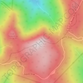
Name: Hawksbill topographic map, elevation, terrain.
Location: Hawksbill, Madison County, Virginia, United States (38.55531 -78.39519 38.55541 -78.39509)
Average elevation: 3,258 ft
Minimum elevation: 2,044 ft
Maximum elevation: 3,993 ft
Madison County trails, hiking, mountain biking, running and outdoor activities
Make a donation
Gear up for your next adventure:
As an Amazon Associate, this site earns from qualifying purchases at no extra cost to you.
Other topographic maps
Click on a map to view its topography, its elevation and its terrain.