Geolocate

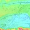
Colomiers topographic map

Click on the map to display elevation.

About this map
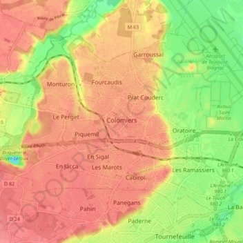
Name: Colomiers topographic map, elevation, terrain.

Location: Colomiers, Toulouse, Haute-Garonne, Occitania, Metropolitan France, 31770, France (43.58931 1.28232 43.63402 1.36676)

Average elevation: 551 ft

Minimum elevation: 456 ft

Maximum elevation: 627 ft

Other topographic maps

Click on a map to view its topography, its elevation and its terrain.
Crouzet

France > Occitania > Haute-Garonne > Saint-Gaudens

Average elevation: 1,227 ft

Luquets

France > Occitania > Haute-Garonne > Buzet-sur-Tarn

Average elevation: 436 ft

La Lune

France > Occitania > Haute-Garonne > Terrebasse

Average elevation: 1,053 ft

Montagnac

France > Occitania > Haute-Garonne > Saint-Frajou

Average elevation: 965 ft

Petit Jean

France > Occitania > Haute-Garonne > Lapeyrère

Average elevation: 1,063 ft

Gear up for your next adventure:

🌡️Portable Weather Meter - Track weather conditions on the trail
🪵Folding Camp Saw - Compact saw for wood and campsite work
🪶Compact Camp Shovel - Folding shovel for campsite tasks
🥄Camping Utensil Set - Lightweight utensils for outdoor meals
🧥Men's Rain Shells - Premium waterproof and breathable jackets for mountain weather

As an Amazon Associate, this site earns from qualifying purchases at no extra cost to you.