Geolocate

Terrasini topographic map

Click on the map to display elevation.

About this map

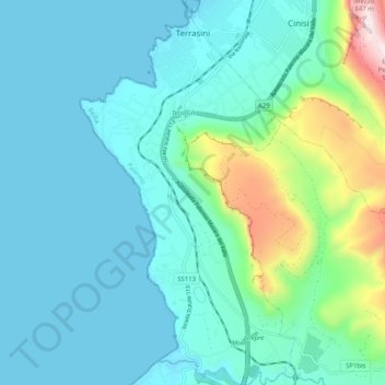
Name: Terrasini topographic map, elevation, terrain.

Location: Terrasini, Palermo, Sicily, 90049, Italy (38.08009 13.05240 38.15960 13.10911)

Average elevation: 515 ft

Minimum elevation: 0 ft

Maximum elevation: 2,959 ft

Other topographic maps

Click on a map to view its topography, its elevation and its terrain.

Sorgente di Montescuro

Italy > Sicily > Palermo > Prizzi

Average elevation: 2,726 ft

Bellacera

Italy > Sicily > Palermo > Santa Flavia

Average elevation: 531 ft

Finale

Italy > Sicily > Palermo

Average elevation: 276 ft

Santa Lucia

Italy > Sicily > Palermo > Cefalù

Average elevation: 167 ft

San Carlo

Italy > Sicily > Palermo > Chiusa Sclafani

Average elevation: 955 ft

Gear up for your next adventure:

👓Polarized Sunglasses - Outdoor sunglasses for glare reduction
🍳Camping Cook Set - Complete cookware for outdoor meals
🪶Survival Guide Book - Expert advice for emergency preparedness
🧴Hand Sanitizer - Keep hands clean while hiking
🌧️Backpack Rain Cover - Keep gear dry in wet weather

As an Amazon Associate, this site earns from qualifying purchases at no extra cost to you.