
Yunmeng County topographic map
Interactive map
Click on the map to display elevation.
About this map
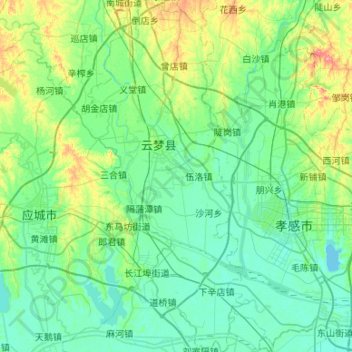
Name: Yunmeng County topographic map, elevation, terrain.
Location: Yunmeng County, Xiaogan City, Hubei, PRC (30.75417 113.62797 31.21002 113.88374)
Average elevation: 115 ft
Minimum elevation: 59 ft
Maximum elevation: 351 ft
Other topographic maps
Click on a map to view its topography, its elevation and its terrain.
Mazongshan
PRC > Hubei > Enshi Tujia and Miao Autonomous Prefecture > Mazongshan
Mazongshan, Badong County, Enshi Tujia and Miao Autonomous Prefecture, Hubei, PRC
Average elevation: 1,404 ft