
Schloss Solitude topographic map
Interactive map
Click on the map to display elevation.
About this map
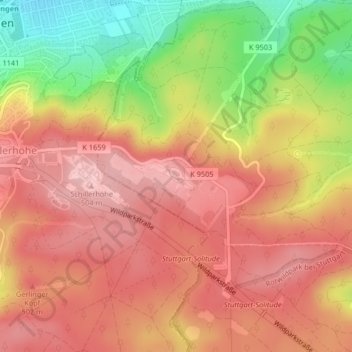
Name: Schloss Solitude topographic map, elevation, terrain.
Average elevation: 1,447 ft
Minimum elevation: 1,076 ft
Maximum elevation: 1,663 ft
Other topographic maps
Click on a map to view its topography, its elevation and its terrain.
Stuttgart
Duitsland > Baden-Württemberg > Stuttgart
Stuttgart, Regierungsbezirk Stuttgart, Baden-Württemberg, 70173, Duitsland
Average elevation: 1,158 ft
Stuttgart-West
Duitsland > Baden-Württemberg > Stuttgart
Stuttgart-West, Stuttgart, Regierungsbezirk Stuttgart, Baden-Württemberg, Duitsland
Average elevation: 1,181 ft