
Robert-Magny topographic map
Interactive map
Click on the map to display elevation.
About this map
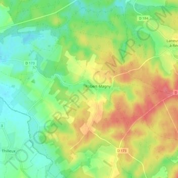
Name: Robert-Magny topographic map, elevation, terrain.
Average elevation: 518 ft
Minimum elevation: 430 ft
Maximum elevation: 633 ft
Other topographic maps
Click on a map to view its topography, its elevation and its terrain.
Montier-en-Der
France > Grand Est > Haute-Marne > La Porte du Der
Montier-en-Der, La Porte du Der, Saint-Dizier, Haute-Marne, Grand Est, France métropolitaine, 52220, France
Average elevation: 459 ft
La Gruyère
France > Grand Est > Haute-Marne > La Porte du Der
La Gruyère, Robert-Magny, La Porte du Der, Saint-Dizier, Haute-Marne, Grand Est, France métropolitaine, 52220, France
Average elevation: 554 ft