
Gronant Dunes topographic map
Interactive map
Click on the map to display elevation.
About this map
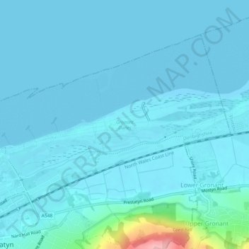
Name: Gronant Dunes topographic map, elevation, terrain.
Location: Gronant Dunes, Prestatyn, Denbighshire, Wales, United Kingdom (53.34442 -3.40156 53.35069 -3.35857)
Average elevation: 36 ft
Minimum elevation: 0 ft
Maximum elevation: 443 ft
Other topographic maps
Click on a map to view its topography, its elevation and its terrain.
Parc Pendre
United Kingdom > Wales > Denbighshire > Prestatyn
Parc Pendre, Prestatyn, Denbighshire, Wales, United Kingdom
Average elevation: 174 ft