
Ourol topographic map
Interactive map
Click on the map to display elevation.
About this map
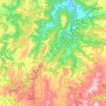
Name: Ourol topographic map, elevation, terrain.
Location: Ourol, Mariña Occidental, Lugo, Galicia, 27865, España (43.48772 -7.75252 43.62019 -7.52032)
Average elevation: 1,506 ft
Minimum elevation: 7 ft
Maximum elevation: 3,438 ft
Other topographic maps
Click on a map to view its topography, its elevation and its terrain.
Chao de Bravos
España > Galicia > Mariña Occidental > Ourol > Chao de Bravos
Chao de Bravos, Bravos, Ourol, Mariña Occidental, Lugo, Galicia, 27865, España
Average elevation: 820 ft