
Thank you for supporting this site ❤️
Make a donation
Make a donation
Gear up for your next adventure:
As an Amazon Associate, this site earns from qualifying purchases at no extra cost to you.
Koshkol' topographic map
Click on the map to display elevation.
Thank you for supporting this site ❤️
Make a donation
Make a donation
Gear up for your next adventure:
As an Amazon Associate, this site earns from qualifying purchases at no extra cost to you.
About this map
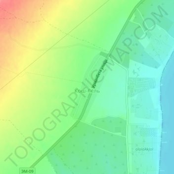
Name: Koshkol' topographic map, elevation, terrain.
Location: Koshkol', Issyk-Kul Region, Kyrgyzstan (42.53516 76.60937 42.54588 76.61844)
Average elevation: 5,335 ft
Minimum elevation: 5,246 ft
Maximum elevation: 5,482 ft
Thank you for supporting this site ❤️
Make a donation
Make a donation
Gear up for your next adventure:
As an Amazon Associate, this site earns from qualifying purchases at no extra cost to you.