
Thank you for supporting this site ❤️
Make a donation
Make a donation
Gear up for your next adventure:
As an Amazon Associate, this site earns from qualifying purchases at no extra cost to you.
Beveren-Leie topographic map
Click on the map to display elevation.
Thank you for supporting this site ❤️
Make a donation
Make a donation
Gear up for your next adventure:
As an Amazon Associate, this site earns from qualifying purchases at no extra cost to you.
About this map
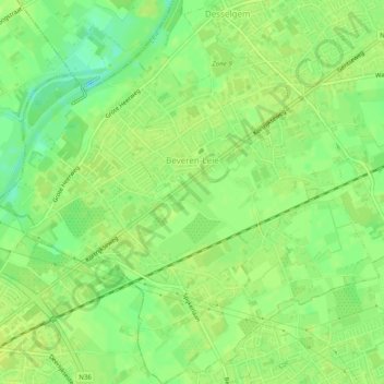
Name: Beveren-Leie topographic map, elevation, terrain.
Location: Beveren-Leie, Waregem, Kortrijk, West Flanders, 8791, Belgium (50.85676 3.32016 50.88766 3.36911)
Average elevation: 49 ft
Minimum elevation: 13 ft
Maximum elevation: 62 ft
Thank you for supporting this site ❤️
Make a donation
Make a donation
Gear up for your next adventure:
As an Amazon Associate, this site earns from qualifying purchases at no extra cost to you.
Other topographic maps
Click on a map to view its topography, its elevation and its terrain.