Geolocate

Bostic topographic map

Click on the map to display elevation.

About this map

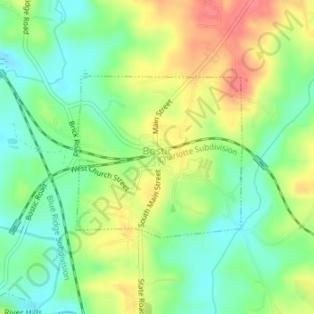
Name: Bostic topographic map, elevation, terrain.

Location: Bostic, Rutherford County, North Carolina, United States (35.35516 -81.84425 35.36908 -81.82669)

Average elevation: 902 ft

Minimum elevation: 797 ft

Maximum elevation: 1,040 ft

Rutherford County trails, hiking, mountain biking, running and outdoor activities

Other topographic maps

Click on a map to view its topography, its elevation and its terrain.

Lake Lure

United States > North Carolina > Rutherford County

Average elevation: 1,191 ft

Whitehouse

United States > North Carolina > Rutherford County

Average elevation: 1,240 ft

Lake Lure

United States > North Carolina > Rutherford County

Average elevation: 1,191 ft

Gear up for your next adventure:

🌡️Portable Weather Meter - Track weather conditions on the trail
🥤Water Filter Bottle - All‑in‑one filter bottle for safe hydration
🎒Trail Energy Bars - High‑calorie bars for hiking energy
🖼️Topo Map Wall Art - Decorative topographic prints of famous peaks and regions
📷Action Cameras - Rugged cameras to document your journeys across rugged terrain

As an Amazon Associate, this site earns from qualifying purchases at no extra cost to you.