
Thank you for supporting this site ❤️
Make a donation
Make a donation
Gear up for your next adventure:
As an Amazon Associate, this site earns from qualifying purchases at no extra cost to you.
Aber-Arad topographic map
Click on the map to display elevation.
Thank you for supporting this site ❤️
Make a donation
Make a donation
Gear up for your next adventure:
As an Amazon Associate, this site earns from qualifying purchases at no extra cost to you.
About this map
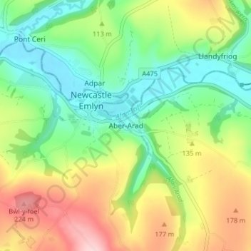
Name: Aber-Arad topographic map, elevation, terrain.
Location: Aber-Arad, Carmarthenshire, Wales, SA38 9DW, United Kingdom (52.01502 -4.47989 52.05502 -4.43989)
Average elevation: 351 ft
Minimum elevation: 62 ft
Maximum elevation: 804 ft
Thank you for supporting this site ❤️
Make a donation
Make a donation
Gear up for your next adventure:
As an Amazon Associate, this site earns from qualifying purchases at no extra cost to you.
Other topographic maps
Click on a map to view its topography, its elevation and its terrain.