
Make a donation
Gear up for your next adventure:
As an Amazon Associate, this site earns from qualifying purchases at no extra cost to you.
Sindangan topographic map
Click on the map to display elevation.
Make a donation
Gear up for your next adventure:
As an Amazon Associate, this site earns from qualifying purchases at no extra cost to you.
Sindangan
Since its elevation to a municipality in 1936, people from Luzon and the Visayas continued migrating to Sindangan to settle together with their families and built businesses. That is why aside from the Subanens, there are Sindanganons whose origins are from Bohol, Cebu, Samar, Leyte, Negros, Bicol, Pampanga, and Manila.
Make a donation
Gear up for your next adventure:
As an Amazon Associate, this site earns from qualifying purchases at no extra cost to you.
About this map
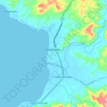
Name: Sindangan topographic map, elevation, terrain.
Average elevation: 98 ft
Minimum elevation: -7 ft
Maximum elevation: 722 ft
Make a donation
Gear up for your next adventure:
As an Amazon Associate, this site earns from qualifying purchases at no extra cost to you.
Other topographic maps
Click on a map to view its topography, its elevation and its terrain.
Make a donation
Gear up for your next adventure:
As an Amazon Associate, this site earns from qualifying purchases at no extra cost to you.