
Aube topographic map
Interactive map
Click on the map to display elevation.
About this map
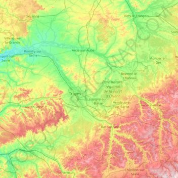
Name: Aube topographic map, elevation, terrain.
Location: Aube, Grand Est, Metropolitan France, France (47.92350 3.38364 48.71672 4.86513)
Average elevation: 571 ft
Minimum elevation: 190 ft
Maximum elevation: 1,371 ft
Other topographic maps
Click on a map to view its topography, its elevation and its terrain.
Toul
France > Grand Est > Meurthe-et-Moselle
Toul, Meurthe-et-Moselle, Grand Est, Metropolitan France, 54200, France
Average elevation: 804 ft
Rolampont
France > Grand Est > Haute-Marne
Rolampont, Langres, Haute-Marne, Grand Est, Metropolitan France, 52260, France
Average elevation: 1,273 ft
Olizy-Primat
Olizy-Primat, Vouziers, Ardennes, Grand Est, Metropolitan France, 08250, France
Average elevation: 505 ft
Les Côtes Jopin
France > Grand Est > Marne > Changy
Les Côtes Jopin, Changy, Vitry-le-François, Marne, Grand Est, Metropolitan France, 51300, France
Average elevation: 433 ft
68116
France > Grand Est > Haut-Rhin > Guewenheim
68116, Guewenheim, Thann-Guebwiller, Haut-Rhin, Grand Est, Metropolitan France, France
Average elevation: 1,119 ft
Château-Salins
Château-Salins, Sarrebourg-Château-Salins, Moselle, Grand Est, Metropolitan France, 57170, France
Average elevation: 794 ft
Cléry-le-Grand
Cléry-le-Grand, Verdun, Meuse, Grand Est, Metropolitan France, 55110, France
Average elevation: 728 ft
Vaux-Champagne
Vaux-Champagne, Vouziers, Ardennes, Grand Est, Metropolitan France, 08130, France
Average elevation: 377 ft
Ville-Houdlémont
France > Grand Est > Meurthe-et-Moselle
Ville-Houdlémont, Val-de-Briey, Meurthe-et-Moselle, Grand Est, Metropolitan France, 54730, France
Average elevation: 958 ft
Nancy
France > Grand Est > Meurthe-et-Moselle
Nancy, Meurthe-et-Moselle, Grand Est, Metropolitan France, France
Average elevation: 755 ft
Chennevières
France > Grand Est > Meuse > Chanteraine
Chennevières, Chanteraine, Bar-le-Duc, Meuse, Grand Est, Metropolitan France, 55500, France
Average elevation: 1,099 ft
Praire
France > Grand Est > Meuse > Sorcy-Saint-Martin
Praire, Sorcy-Saint-Martin, Commercy, Meuse, Grand Est, Metropolitan France, 55190, France
Average elevation: 827 ft
Fort St Michel
France > Grand Est > Meuse > Belleville-sur-Meuse
Fort St Michel, Chemin strategique n° 2, Quartier Bayard, Belleville-sur-Meuse, Verdun, Meuse, Grand Est, Metropolitan France, 55430, France
Average elevation: 896 ft
Dogneville
Dogneville, Épinal, Vosges, Grand Est, Metropolitan France, 88000, France
Average elevation: 1,106 ft
Berrwiller
France > Grand Est > Haut-Rhin
Berrwiller, Mulhouse, Haut-Rhin, Grand Est, Metropolitan France, 68500, France
Average elevation: 889 ft
Mansard
France > Grand Est > Meuse > Dombasle-en-Argonne
Mansard, Dombasle-en-Argonne, Verdun, Meuse, Grand Est, Metropolitan France, 55120, France
Average elevation: 935 ft
Eschwiller
Eschwiller, Saverne, Bas-Rhin, Grand Est, Metropolitan France, 67320, France
Average elevation: 988 ft
La Puce
France > Grand Est > Meurthe-et-Moselle > Boismont
La Puce, Boismont, Val-de-Briey, Meurthe-et-Moselle, Grand Est, Metropolitan France, 54620, France
Average elevation: 938 ft
Dommartin-lès-Toul
France > Grand Est > Meurthe-et-Moselle
Dommartin-lès-Toul, Toul, Meurthe-et-Moselle, Grand Est, Metropolitan France, 54200, France
Average elevation: 748 ft
Ath
France > Grand Est > Bas-Rhin > Diemeringen
Ath, Diemeringen, Saverne, Bas-Rhin, Grand Est, Metropolitan France, 67430, France
Average elevation: 837 ft
Mourmelon-le-Grand
Mourmelon-le-Grand, Châlons-en-Champagne, Marne, Grand Est, Metropolitan France, 51400, France
Average elevation: 407 ft
Saint-Memmie
Saint-Memmie, Châlons-en-Champagne, Marne, Grand Est, Metropolitan France, 51470, France
Average elevation: 322 ft
Croix Allart
France > Grand Est > Marne > Bétheny
Croix Allart, Bétheny, Reims, Marne, Grand Est, Metropolitan France, 51450, France
Average elevation: 308 ft
Saint-Brice-Courcelles
Saint-Brice-Courcelles, Reims, Marne, Grand Est, Metropolitan France, 51370, France
Average elevation: 259 ft
Montmirail
Montmirail, Épernay, Marne, Grand Est, Metropolitan France, 51210, France
Average elevation: 617 ft
Nogent
France > Grand Est > Haute-Marne
Nogent, Chaumont, Haute-Marne, Grand Est, Metropolitan France, 52800, France
Average elevation: 1,309 ft
Witry-lès-Reims
Witry-lès-Reims, Reims, Marne, Grand Est, Metropolitan France, 51420, France
Average elevation: 390 ft
Vitry-le-François
Vitry-le-François, Marne, Grand Est, Metropolitan France, 51300, France
Average elevation: 331 ft
Aÿ-Champagne
Aÿ-Champagne, Épernay, Marne, Grand Est, Metropolitan France, France
Average elevation: 417 ft
Cormontreuil
Cormontreuil, Reims, Marne, Grand Est, Metropolitan France, 51350, France
Average elevation: 322 ft
Villers-Semeuse
Villers-Semeuse, Charleville-Mézières, Ardennes, Grand Est, Metropolitan France, 08000, France
Average elevation: 522 ft