
Cardigos topographic map
Interactive map
Click on the map to display elevation.
About this map
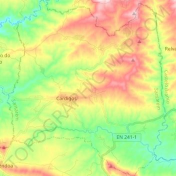
Name: Cardigos topographic map, elevation, terrain.
Location: Cardigos, Mação, Santarém, 6120-612, Portugal (39.65284 -8.06237 39.74783 -7.94973)
Average elevation: 1,194 ft
Minimum elevation: 682 ft
Maximum elevation: 1,870 ft
Other topographic maps
Click on a map to view its topography, its elevation and its terrain.
Chão de Lopes Pequeno
Portugal > Santarém > Mação > Amêndoa
Chão de Lopes Pequeno, Amêndoa, Mação, Santarém, Portugal
Average elevation: 1,234 ft
Castelo Velho
Castelo Velho, Mação, Santarém, 6120-069, Portugal
Average elevation: 676 ft
Pêro Gonçalves
Pêro Gonçalves, Amêndoa, Mação, Santarém, Portugal
Average elevation: 1,165 ft