
Arun River topographic map
Interactive map
Click on the map to display elevation.
About this map
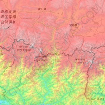
Name: Arun River topographic map, elevation, terrain.
Location: Arun River, Tingri County, Shigatse, Tibet, PRC (26.91545 85.87171 28.81249 87.63234)
Average elevation: 12,333 ft
Minimum elevation: 548 ft
Maximum elevation: 28,009 ft
Other topographic maps
Click on a map to view its topography, its elevation and its terrain.
Changla
PRC > Tibet > Ngari Prefecture > Hor Town
Changla, Hor Town, Burang County, Ngari Prefecture, Tibet, PRC
Average elevation: 19,665 ft
Yarlung Zangbo
Yarlung Zangbo, Qüxü, Qüxü County, Lhasa, Tibet, PRC
Average elevation: 11,965 ft