
Maragüez topographic map
Interactive map
Click on the map to display elevation.
About this map
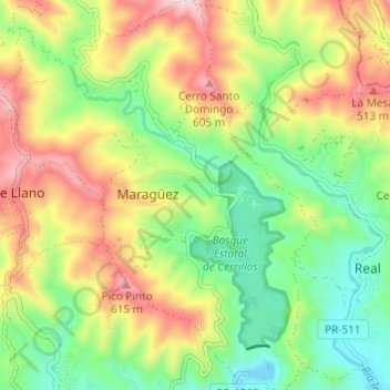
Name: Maragüez topographic map, elevation, terrain.
Location: Maragüez, Ponce, Puerto Rico, United States (18.07000 -66.61754 18.12776 -66.56862)
Average elevation: 1,056 ft
Minimum elevation: 315 ft
Maximum elevation: 2,116 ft
Other topographic maps
Click on a map to view its topography, its elevation and its terrain.
Cerro de Punta
United States > Puerto Rico > Ponce
Cerro de Punta, Ponce, Puerto Rico, 00654, United States
Average elevation: 3,350 ft
Anón
United States > Puerto Rico > Ponce
Anón, Ponce, Puerto Rico, United States
Average elevation: 2,195 ft