
Kabare (chefferie) topographic map
Interactive map
Click on the map to display elevation.
About this map
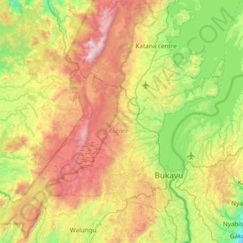
Name: Kabare (chefferie) topographic map, elevation, terrain.
Average elevation: 6,030 ft
Minimum elevation: 3,323 ft
Maximum elevation: 10,535 ft
Other topographic maps
Click on a map to view its topography, its elevation and its terrain.
Kamakombe
Democratic Republic of the Congo > South Kivu > Kabare > Kamakombe
Kamakombe, Kabare (chefferie), Kabare, South Kivu, Democratic Republic of the Congo
Average elevation: 5,774 ft