
Ingham Mills topographic map
Interactive map
Click on the map to display elevation.
About this map
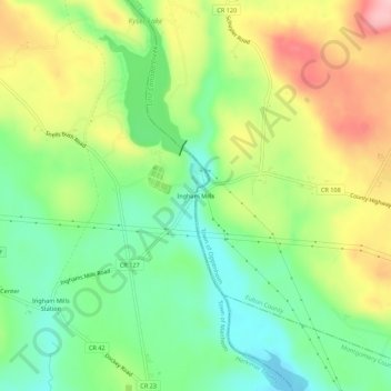
Name: Ingham Mills topographic map, elevation, terrain.
Average elevation: 705 ft
Minimum elevation: 482 ft
Maximum elevation: 1,024 ft
Other topographic maps
Click on a map to view its topography, its elevation and its terrain.
East Creek
United States > New York > Herkimer County > Town of Manheim
East Creek, Town of Manheim, Herkimer County, New York, United States
Average elevation: 456 ft
Ingham Mills Station
United States > New York > Herkimer County > Town of Manheim
Ingham Mills Station, Town of Manheim, Herkimer County, New York, United States
Average elevation: 620 ft
Manheim Center
United States > New York > Herkimer County > Town of Manheim
Manheim Center, Town of Manheim, Herkimer County, New York, United States
Average elevation: 643 ft