
Town of Watertown topographic map
Interactive map
Click on the map to display elevation.
About this map
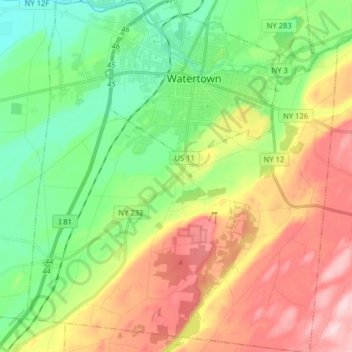
Name: Town of Watertown topographic map, elevation, terrain.
Location: Town of Watertown, Jefferson County, New York, United States (43.88506 -75.98706 44.00025 -75.84560)
Average elevation: 620 ft
Minimum elevation: 285 ft
Maximum elevation: 1,115 ft
Other topographic maps
Click on a map to view its topography, its elevation and its terrain.
Village of Evans Mills
United States > New York > Jefferson County
Village of Evans Mills, Town of Le Ray, Jefferson County, New York, United States
Average elevation: 456 ft
Just Room Enough Island
United States > New York > Jefferson County > Village of Alexandria Bay
Just Room Enough Island, Village of Alexandria Bay, Town of Alexandria, Jefferson County, New York, United States
Average elevation: 256 ft
Village of Black River
United States > New York > Jefferson County
Village of Black River, Town of Le Ray, Jefferson County, New York, United States
Average elevation: 633 ft
Village of Philadelphia
United States > New York > Jefferson County
Village of Philadelphia, Town of Philadelphia, Jefferson County, New York, 13673, United States
Average elevation: 489 ft
Village of Theresa
United States > New York > Jefferson County > Town of Theresa
Village of Theresa, Town of Theresa, Jefferson County, New York, 13691, United States
Average elevation: 397 ft
Black River
United States > New York > Jefferson County > Black River
Black River, Le Ray, Jefferson County, New York, 13612, United States
Average elevation: 620 ft
Whites Bay
United States > New York > Jefferson County
Whites Bay, Henderson, Jefferson County, New York, 13651, United States
Average elevation: 299 ft